Property Record
12220 Birmingham Hwy, Alpharetta, GA 30004

NEARBY LISTINGS FOR SALE OR LEASE
Property Detail
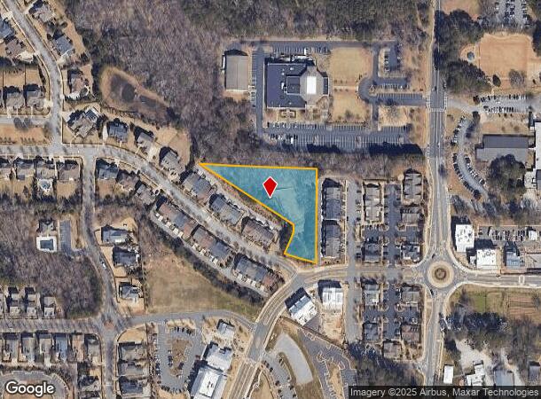
12220 Birmingham Hwy
Atlanta-Sandy Springs-Roswell, GA
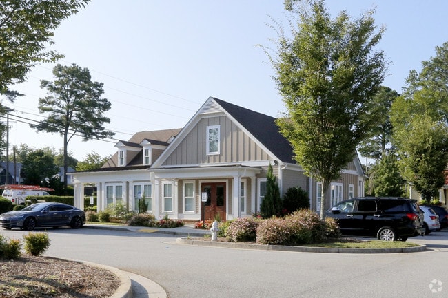
Braeburn Office Village
22-4001-1135-028-2
VACANT LOT CB22 3/2021 NO IMPROVEMENTS
Residentialacreage
Fulton
X
Georgia
13057C0380E
1098
2024
1.49 AC
2025
N Fulton/Forsyth County
011510
Atlanta
DEMOGRAPHICS near 12220 Birmingham Hwy
1 Mile
3 Mile
5 Mile
2024 Total Population
5,892
40,454
120,850
2029 Population
6,011
41,310
124,339
Pop Growth 2024-2029
+ 2.02%
+ 2.12%
+ 2.89%
Average Age
39
40
40
2024 Total Households
1,874
14,121
46,120
HH Growth 2024-2029
+ 2.03%
+ 2.27%
+ 3.05%
Median Household Inc
$186,136
$165,898
$129,532
Avg Household Size
3.10
2.80
2.60
2024 Avg HH Vehicles
2.00
2.00
2.00
Median Home Value
$592,066
$516,249
$488,465
Median Year Built
1998
1993
1994
Nearby Places
Map Layers
Map Styles
 Street
 Aerial
- Restaurants
- Banks
- Shops
- Fitness
- Groceries
Nearby Properties
Address
Land Use
TOTAL SIZE
Lot Size
Zoning
Address
Land Use
TOTAL SIZE
Lot Size
Zoning
3,459,339 SF
26.51 AC
OI
Address
Land Use
TOTAL SIZE
Lot Size
Zoning
11.82 AC
Address
Land Use
TOTAL SIZE
Lot Size
Zoning
260,648 SF
34.20 AC
C3C
Address
Land Use
TOTAL SIZE
Lot Size
Zoning
2,674,992 SF
28.94 AC
R4C
Address
Land Use
TOTAL SIZE
Lot Size
Zoning
308,494 SF
2.64 AC
OI
Address
Land Use
TOTAL SIZE
Lot Size
Zoning
2,289 SF
84.27 AC
AG1
Address
Land Use
TOTAL SIZE
Lot Size
Zoning
286,394 SF
39.10 AC
R1
Address
Land Use
TOTAL SIZE
Lot Size
Zoning
306,753 SF
19.77 AC
HMS
Address
Land Use
TOTAL SIZE
Lot Size
Zoning
3,727,094 SF
5.92 AC
OI
Address
Land Use
TOTAL SIZE
Lot Size
Zoning
1,199,716 SF
7.10 AC
C1
Address
Land Use
TOTAL SIZE
Lot Size
Zoning
32.02 AC
Address
Land Use
TOTAL SIZE
Lot Size
Zoning
34.89 AC
C2
Address
Land Use
TOTAL SIZE
Lot Size
Zoning
259,641 SF
16.76 AC
I1C
Address
Land Use
TOTAL SIZE
Lot Size
Zoning
183,216 SF
15.02 AC
C3C
Address
Land Use
TOTAL SIZE
Lot Size
Zoning
1,175 SF
40.66 AC
AG1
Address
Land Use
TOTAL SIZE
Lot Size
Zoning
37.61 AC
AG1
Address
Land Use
TOTAL SIZE
Lot Size
Zoning
185,520 SF
23.28 AC
AG1
Address
Land Use
TOTAL SIZE
Lot Size
Zoning
25.90 AC
E2
Address
Land Use
TOTAL SIZE
Lot Size
Zoning
22 AC
C2
Address
Land Use
TOTAL SIZE
Lot Size
Zoning
154,764 SF
14.70 AC
C1
Address
Land Use
TOTAL SIZE
Lot Size
Zoning
173,529 SF
19.80 AC
OI
Address
Land Use
TOTAL SIZE
Lot Size
Zoning
28.08 AC
E2
Address
Land Use
TOTAL SIZE
Lot Size
Zoning
123,470 SF
0.18 AC
C1
Address
Land Use
TOTAL SIZE
Lot Size
Zoning
405,500 SF
6 AC
OI
Address
Land Use
TOTAL SIZE
Lot Size
Zoning
62.94 AC
SU
Address
Land Use
TOTAL SIZE
Lot Size
Zoning
93,167 SF
2.57 AC
C3C
Address
Land Use
TOTAL SIZE
Lot Size
Zoning
235,471 SF
21.70 AC
I1C
Address
Land Use
TOTAL SIZE
Lot Size
Zoning
85,000 SF
6.14 AC
AG1
Address
Land Use
TOTAL SIZE
Lot Size
Zoning
81,095 SF
10.49 AC
C3C
Address
Land Use
TOTAL SIZE
Lot Size
Zoning
36.47 AC
SU
The World's #1 Commercial Real Estate Marketplace
Connect with us
© 2025 CoStar Group
The information above has been obtained from sources believed reliable. While we do not doubt its accuracy we have not verified it and make no guarantee, warranty or representation about it. It is your responsibility to independently confirm its accuracy and completeness. Any projections, opinions, assumptions, or estimates used are for example only and do not represent the current or future performance of the property. The value of this transaction to you depends on tax and other factors which should be evaluated by your tax, financial, and legal advisors. You and your advisors should conduct a careful, independent investigation of the property to determine to your satisfaction the suitability of the property for your needs.